
Franz Josef Land archipelago is the closest land to the North Pole in the eastern hemisphere (about 870 km to the North Pole).
It has been discovered in 1873 by the Austrian - Hungarian "Tegetthoff" expedition, under the leadership of Carl Weyprecht, who named the islands after Emperor Franz Joseph I.
The extremely northern position of the islands attracted expeditions of the pioneer age (late 19th - early 20th century), which usually saw Franz Josef Land as a useful advanced base for attempts to reach the North Pole.
The archipelago was more fully explored by expeditions such as one led by Nansen (who spent the winter of 1895–96 in Franz Josef Land).
 Flat tabletop mountains are characteristic of Franz Joseph islands.
In 1926 the islands were taken over by the Soviet Union, for research and military purposes; many of the Russian Polar stations are now abandoned, and the whole archipelago is given back to the wildlife. Polar Bears, walruses, arctic foxes, belugas and whales, and lots of Arctic birds.
 Polar bears at Rudolf Island
Nowadays it is one of rare 'wild' places left on Earth - it is unpopulated except for one permanent Russian base.

The archipelago consists of 191 islands, mostly covered with a permanent ice cap. Islands of volcanic origin, including Alexandra Land, Prince George Land, Bell Island, Hooker Island, Prince Rudolf Island, Hall island...
Hall Island (Ostrov Gallya)
80°05′ N, 58°01′ E
A medium size island, mostly under ice cap, Hall island was discovered on 1873 by the Austro-Hungarian North Pole Expedition led by Weyprecht.

Later, in 1898-99 a small camp was built at Cape Tegetthoff, one of the most spectacular views on the islands, and the best known landmark (figuring on the logo).

Cape Tegetthoff was named after the main ship of the Austro-Hungarian explorers.

On the southern coast of the island sights are very impressive: huge cliffs resembling dorsal fins of gigantic sharks submerge into the depths.

This chain of spectacular rock towers, terminating in two pointed rock needles just off the coast, are one of the most fantastic sceneries of the whole archipelago.

Some remains of the stations built by polar expeditions can still be observed at cape Tegetthoff.
 The "Tegetthoff" leaving.
The remains of the wooden structures built later by the Wellman's expedition (1898-1899), which failed to reach the north pole, are better preserved, and ad further drama to the landscape:
 Wellman's octogonal wintering hut remains.
Northbrook island (Ostrov Nortbruk)
79.9° N, 50.9° E

One of the most accessible locations in the island group, it often served as a base for polar expeditions in the late 19th and early 20th centuries.
 Cape Flora
 Cape Flora
 Cape Flora, located in an unglacierized area in the Southwest of Northbrook Island camp, is historically significant.
Lee Smith 's expedition in 1880 shipwrecked here:
 The "Eira" sinking
Ben Lee Smith's "Eira" unexpectedly turned out to be between two icebergs in sight of Cape Flora . The ship sank in a matter of hours. The crew escaped and managed to get ashore.
Many years later, in 1896, a chance encounter between explorers Nansen and Jackson took place here. Jackson was based at Cape Flora, when this meeting occurred. A memorial was built:

Bell Island
81°09′ N, 64°17′ E
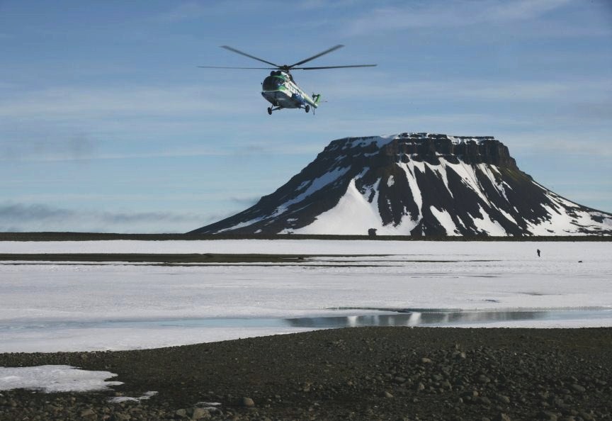
The landscape of Bell Island is majestic: the cliffs and ice-capped mountains are the highest on the archipelago.

Bell island is famous for its tabular mountain shape and easy to visit (there is a helicopter landing site)


Bell island is famous for its tabular mountain shape and easy to visit (there is a helicopter landing site)
Eira Lodge, built in 1881 by the british Leigh Smith's expedition on Bell Island (named after the shape of the mountain), is the oldest building 1n the archipelago.


 View of the Bell island's flat top shape from Eira lodge cabin.
Champ Island
80.67°N, 56.23°E
 The main features of this rocky island are its geological spheric stone balls, up to 3 m in diameter.
 These stones of spherical shape are called geodes.
Hooker Island (Ostrov Gukera)
80.23° N, 53.02° E.
 Mount Churlyanisa, Hooker Island
One of the most important islands, with an old russian polar station (now abandoned) on the western shore of Tikhaya Bay, in an unglaciated area.

The famous Rubini Rock, a huge basaltic cliff in the bay, is the shelter for thousands of cliff-nesting sea birds.
 Mighty basaltic Rubini Rock protrudes into Tikhaya Bay.
 In 1929, the first Soviet research station was established in Tikhaya Bay. Tikhaya station is remarkably well preserved.
Prince George Land (Zemlya Georga)
80°26′ N, 49°00′ E

This is both the biggest and the longest (115 km) island in Franz-Josef-Land.
 Cape Grant
 Cape Grant
As typical for most parts of the archipelago, it consists of extensive complexes of tabular mountains, which are mostly covered under ice caps, a few steep rock capes peek out of the ice along the coastlines.
 Waterfall at Cape Desires
Alexandra Island (Zemlya Aleksandry)
and Nagurskoye
80° 48′ N, 47° 36′ E
The most western island of the archipelago, Alexandra Island is mainly the location of the main populated settlement in the archipelago: the russian base Nagurskoye.

An extremely remote Arctic base, Nagurskoye was built in 1950 for military purposes, and after a long decay is now modernised and converted to arctic studies.
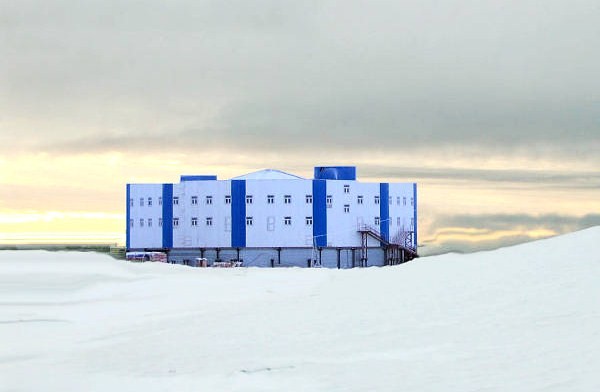
An extremely remote Arctic base, Nagurskoye was built in 1950 for military purposes, and after a long decay is now modernised and converted to arctic studies.

The base has served as an important weather station in the archipelago during the Cold War. It's also the world's northernmost border post - of the Russian northern frontier.
 Saint Nicholas Church, a pre-built wooden church for the lonesome crew.
Hayes island (Ostrov Heiss)
80°37′ N, 58°03′ E
Small, mostly flat and low, Hayes or Heiss island is almost unglacierized, having only a small ice-cap off its centre by its northern shore.
On the northeastern tip of the island, there is a shallow old meteorite crater filled with fresh water. There the buildings of the old russian Krenkel Station line up on its low rim.
 An almost surrealistic picture: station buildings around the crater
A new, clean and much smaller modern station made of prefabricated modules was set up between the old buildings since 2004, and is operational all-year round with a small team of about 5 persons.

The northernmost post office in the world is located here on Heiss Island, at Krenkel station:
 Russian Post, station nº 163100
Prince Rudolf Land
81.76° N, 58.56° E
 This is the northermost island, permanently ice-covered and close to the north pole. Rudolf Island is almost completely glaciated.
  Edge of the Ice Cap, Rudolf Island
Because of its location, the island has served as a staging area for numerous polar expeditions.
 The ship America in Teplitz Bay - the expedition failed to reach the pole (1904)
Cape Fligely, located on Rudolf Island's northern shore, is the northernmost point of Europe and Russia.

----------------------------------------------------
 Austrian postage stamp celebrating the discovery of Franz Josef Land
 Austrian postage stamp celebrating the discovery of Franz Josef Land
 The Nansen and Johansen voyage through the archipelago, 1895-1896.
--------------------------------------------------
Further reading:
0 comments:
Post a Comment